 Catalogo de metadatos del IGME
Geological Survey of Spain (IGME)
Type of resources
Available actions
Topics
Keywords
Contact for the resource
Provided by
Years
Formats
Representation types
Update frequencies
status
Service types
Scale
-
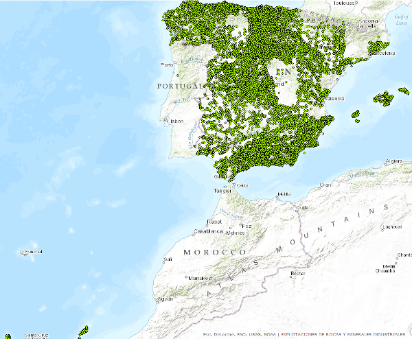
WFS service provides access to basic information related to the mining operations (both abandoned or operating continuously or intermittently) and minerals occurrences of industrial minerals and rocks. Service was created in the framework of the Minerals4EU project and its harmonizated according to the INSPIRE requeriments-
-

Dataset contains information related to the mining operations (both abandoned or operating continuously or intermittently) and minerals occurrences of industrial minerals and rocks. These data have been generated by the IGME along numerous projects since the early 70s to the present. It has national coverage.
-
WFS service provides access to basic information related to the mining operations (both abandoned or operating continuously or intermittently) and minerals occurrences of industrial minerals and rocks. Service was created in the framework of the Minerals4EU project and its harmonizated according to the INSPIRE requeriments-
-
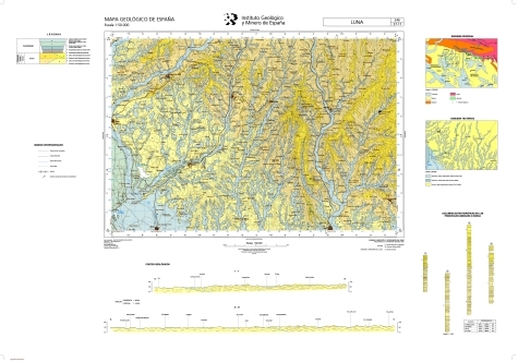
The sheet 246 (LUNA) of the National Geological Map (MAGNA), was made in 2008 and published in 2009 by the Geological Survey of Spain. It is distributed at scale 50000. The geological map shows the nature of materials (rocks and sediments) that appear on the surface, their spatial distribution and geometric relationships between the different cartographic units represented. A geological mapping unit is the grouping of one or more lithologies with common age range, which is represented on the map at a scale or defined resolution. Each mapping unit, and the different geological structures, is represented on the map with a symbolism itself. The representation of these units on the topographic base map provides some three-dimensional information that is completed with other geological data and geological sections, stratigraphic profiles, polls, etc. The map legend is a pictogram representing the spatial relationship of the different mapping units (chronology, overlapping, geometric relationship, lateral facies changes, etc.). It also includes structural, hydrogeological and geological location of the sheet within the regional schemes. Since 1991, the Geological Map Series MAGNA is made inseparably with the geomorphological map on the same scale. This map incorporates everything on the surface geology and provides a structured and accurate information of the land forms. It is organized on the basis of morphogenesis and morphocronology incorporated the map using the corresponding chronostratigraphic column included in a table / legend inspired by the geological map. The forms, erosional and depositional, are represented on the map by individualized by symbols and patterns of color and surface deposits or lithological formations elements that provide information. For each sheet of the series MAGNA there is an explanatory report published, edited and in digital format. The digital information is stored in coverage and Shape format (ESRI). There is a guide that describes the physical structure of the digital information and its codification.
-
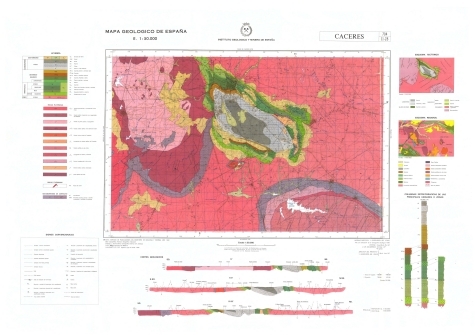
The sheet 704 (CÁCERES) of the National Geological Map (MAGNA), was made in 1982 and published in 1997 by the Geological Survey of Spain. It is distributed at scale 50000. The geological map shows the nature of materials (rocks and sediments) that appear on the surface, their spatial distribution and geometric relationships between the different cartographic units represented. A geological mapping unit is the grouping of one or more lithologies with common age range, which is represented on the map at a scale or defined resolution. Each mapping unit, and the different geological structures, is represented on the map with a symbolism itself. The representation of these units on the topographic base map provides some three-dimensional information that is completed with other geological data and geological sections, stratigraphic profiles, polls, etc. The map legend is a pictogram representing the spatial relationship of the different mapping units (chronology, overlapping, geometric relationship, lateral facies changes, etc.). It also includes structural, hydrogeological and geological location of the sheet within the regional schemes. Since 1991, the Geological Map Series MAGNA is made inseparably with the geomorphological map on the same scale. This map incorporates everything on the surface geology and provides a structured and accurate information of the land forms. It is organized on the basis of morphogenesis and morphocronology incorporated the map using the corresponding chronostratigraphic column included in a table / legend inspired by the geological map. The forms, erosional and depositional, are represented on the map by individualized by symbols and patterns of color and surface deposits or lithological formations elements that provide information. For each sheet of the series MAGNA there is an explanatory report published, edited and in digital format. The digital information is stored in coverage and Shape format (ESRI). There is a guide that describes the physical structure of the digital information and its codification.
-
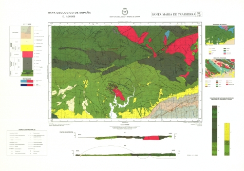
The sheet 922 (SANTA MARÍA DE TRASSIERRA) of the National Geological Map (MAGNA), was made in 1975 and published in 1995 by the Geological Survey of Spain. It is distributed at scale 50000. The geological map shows the nature of materials (rocks and sediments) that appear on the surface, their spatial distribution and geometric relationships between the different cartographic units represented. A geological mapping unit is the grouping of one or more lithologies with common age range, which is represented on the map at a scale or defined resolution. Each mapping unit, and the different geological structures, is represented on the map with a symbolism itself. The representation of these units on the topographic base map provides some three-dimensional information that is completed with other geological data and geological sections, stratigraphic profiles, polls, etc. The map legend is a pictogram representing the spatial relationship of the different mapping units (chronology, overlapping, geometric relationship, lateral facies changes, etc.). It also includes structural, hydrogeological and geological location of the sheet within the regional schemes. Since 1991, the Geological Map Series MAGNA is made inseparably with the geomorphological map on the same scale. This map incorporates everything on the surface geology and provides a structured and accurate information of the land forms. It is organized on the basis of morphogenesis and morphocronology incorporated the map using the corresponding chronostratigraphic column included in a table / legend inspired by the geological map. The forms, erosional and depositional, are represented on the map by individualized by symbols and patterns of color and surface deposits or lithological formations elements that provide information. For each sheet of the series MAGNA there is an explanatory report published, edited and in digital format. The digital information is stored in coverage and Shape format (ESRI). There is a guide that describes the physical structure of the digital information and its codification.
-
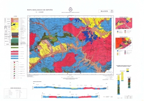
The sheet 365 (BLANES) of the National Geological Map (MAGNA), was made in 1983 and published in 2010 by the Geological Survey of Spain. It is distributed at scale 50000. The geological map shows the nature of materials (rocks and sediments) that appear on the surface, their spatial distribution and geometric relationships between the different cartographic units represented. A geological mapping unit is the grouping of one or more lithologies with common age range, which is represented on the map at a scale or defined resolution. Each mapping unit, and the different geological structures, is represented on the map with a symbolism itself. The representation of these units on the topographic base map provides some three-dimensional information that is completed with other geological data and geological sections, stratigraphic profiles, polls, etc. The map legend is a pictogram representing the spatial relationship of the different mapping units (chronology, overlapping, geometric relationship, lateral facies changes, etc.). It also includes structural, hydrogeological and geological location of the sheet within the regional schemes. Since 1991, the Geological Map Series MAGNA is made inseparably with the geomorphological map on the same scale. This map incorporates everything on the surface geology and provides a structured and accurate information of the land forms. It is organized on the basis of morphogenesis and morphocronology incorporated the map using the corresponding chronostratigraphic column included in a table / legend inspired by the geological map. The forms, erosional and depositional, are represented on the map by individualized by symbols and patterns of color and surface deposits or lithological formations elements that provide information. For each sheet of the series MAGNA there is an explanatory report published, edited and in digital format. The digital information is stored in coverage and Shape format (ESRI). There is a guide that describes the physical structure of the digital information and its codification.
-
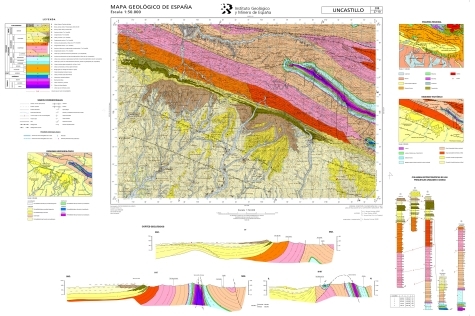
The sheet 208 (UNCASTILLO) of the National Geological Map (MAGNA), was made in 2009 and published in 2012 by the Geological Survey of Spain. It is distributed at scale 50000. The geological map shows the nature of materials (rocks and sediments) that appear on the surface, their spatial distribution and geometric relationships between the different cartographic units represented. A geological mapping unit is the grouping of one or more lithologies with common age range, which is represented on the map at a scale or defined resolution. Each mapping unit, and the different geological structures, is represented on the map with a symbolism itself. The representation of these units on the topographic base map provides some three-dimensional information that is completed with other geological data and geological sections, stratigraphic profiles, polls, etc. The map legend is a pictogram representing the spatial relationship of the different mapping units (chronology, overlapping, geometric relationship, lateral facies changes, etc.). It also includes structural, hydrogeological and geological location of the sheet within the regional schemes. Since 1991, the Geological Map Series MAGNA is made inseparably with the geomorphological map on the same scale. This map incorporates everything on the surface geology and provides a structured and accurate information of the land forms. It is organized on the basis of morphogenesis and morphocronology incorporated the map using the corresponding chronostratigraphic column included in a table / legend inspired by the geological map. The forms, erosional and depositional, are represented on the map by individualized by symbols and patterns of color and surface deposits or lithological formations elements that provide information. For each sheet of the series MAGNA there is an explanatory report published, edited and in digital format. The digital information is stored in coverage and Shape format (ESRI). There is a guide that describes the physical structure of the digital information and its codification.
-
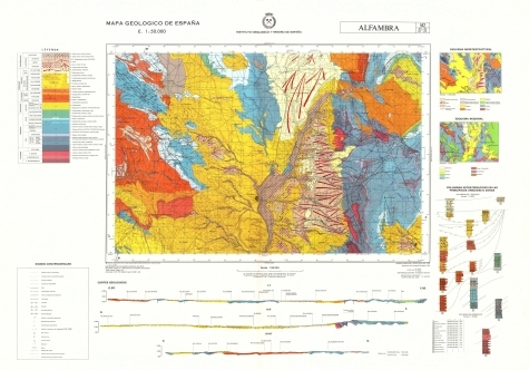
The sheet 542 (ALFAMBRA) of the National Geological Map (MAGNA), was made in 1983 and published in 1995 by the Geological Survey of Spain. It is distributed at scale 50000. The geological map shows the nature of materials (rocks and sediments) that appear on the surface, their spatial distribution and geometric relationships between the different cartographic units represented. A geological mapping unit is the grouping of one or more lithologies with common age range, which is represented on the map at a scale or defined resolution. Each mapping unit, and the different geological structures, is represented on the map with a symbolism itself. The representation of these units on the topographic base map provides some three-dimensional information that is completed with other geological data and geological sections, stratigraphic profiles, polls, etc. The map legend is a pictogram representing the spatial relationship of the different mapping units (chronology, overlapping, geometric relationship, lateral facies changes, etc.). It also includes structural, hydrogeological and geological location of the sheet within the regional schemes. Since 1991, the Geological Map Series MAGNA is made inseparably with the geomorphological map on the same scale. This map incorporates everything on the surface geology and provides a structured and accurate information of the land forms. It is organized on the basis of morphogenesis and morphocronology incorporated the map using the corresponding chronostratigraphic column included in a table / legend inspired by the geological map. The forms, erosional and depositional, are represented on the map by individualized by symbols and patterns of color and surface deposits or lithological formations elements that provide information. For each sheet of the series MAGNA there is an explanatory report published, edited and in digital format. The digital information is stored in coverage and Shape format (ESRI). There is a guide that describes the physical structure of the digital information and its codification.
-
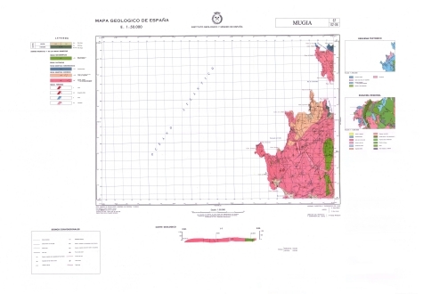
The sheet 67 (MUXÍA) of the National Geological Map (MAGNA), was made in 1981 by the Geological Survey of Spain. It is distributed at scale 50000. The geological map shows the nature of materials (rocks and sediments) that appear on the surface, their spatial distribution and geometric relationships between the different cartographic units represented. A geological mapping unit is the grouping of one or more lithologies with common age range, which is represented on the map at a scale or defined resolution. Each mapping unit, and the different geological structures, is represented on the map with a symbolism itself. The representation of these units on the topographic base map provides some three-dimensional information that is completed with other geological data and geological sections, stratigraphic profiles, polls, etc. The map legend is a pictogram representing the spatial relationship of the different mapping units (chronology, overlapping, geometric relationship, lateral facies changes, etc.). It also includes structural, hydrogeological and geological location of the sheet within the regional schemes. Since 1991, the Geological Map Series MAGNA is made inseparably with the geomorphological map on the same scale. This map incorporates everything on the surface geology and provides a structured and accurate information of the land forms. It is organized on the basis of morphogenesis and morphocronology incorporated the map using the corresponding chronostratigraphic column included in a table / legend inspired by the geological map. The forms, erosional and depositional, are represented on the map by individualized by symbols and patterns of color and surface deposits or lithological formations elements that provide information. For each sheet of the series MAGNA there is an explanatory report published, edited and in digital format. The digital information is stored in coverage and Shape format (ESRI). There is a guide that describes the physical structure of the digital information and its codification.